€9.500,00 Categories: Cartography/Globes, Geschiedenis, History 1772 - London, Robert Sayer Nr. 12600
Large World map by Samuel Dunn, 140 x 120 cm. “London, Printed for Rob.t Sayer, Map & Printseller, No. 53 in Fleet Street, as the Act directs, 20th November 1772.” “S. Dunn Teacher of the Mathematics LONDON. Boards Young Gentlemen, & Teacheth Pennmannship, Merch.ts, Acc.ts, Navigation, Fortification, Astronomy &c. CHELSEA”. Pasted text on top left [...]

€1.250,00 Category: Cartography/Globes 1677 - Dordrecht, Symon Onder de Linde Nr. 12528
2 delen, (titelprent, 1, portret,16) 688, 689-1358 (22) p. p. Origineel Leer met ribben, goud-bestempeld, 4° Beschrijving van de stad Dordrecht door Matthys Balen 1611-1691, het werk bevat een toegankelijke beschrijving van de vroege geschiedenis van deze belangrijke Nederlandse stad. Rijkelijk geïllustreerd met een titelprent, een portret van Balen, beide gegraveerd door Romeyn de Hooghe, [...]

€900,00 Categories: Cartography/Globes, New Acquisitions, New York 2026 1745 - London, Thomas Wright Nr. 12536
(VIII) 190 p. Contemporary gold-stamped Leather, large 8°. With 7 folding plates, complete. Made for Thomas Wright, mathematical instrument-maker and E. Cushee, globe-maker at the Globe and Sun, between St. Dunstan’s Church and Chancery-Lane, both in Fleet-Street. Joseph Harris (1703-1764), was a blacksmith, astronomer, navigator, economist, natural philosopher and government adviser and King’s assay Master [...]
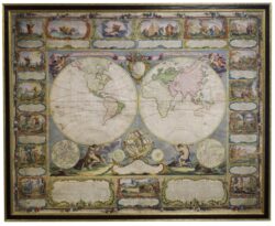
€22.500,00 Categories: Cartography/Globes, Highlights 1754 - Paris, Longchamps et Janvier Nr. 12551
Wall map of the world in two hemispheres printed on two sheets, depicting the Eastern and Western hemispheres supported by two male figures, decorated at the bottom right and left with two celestial hemispheres (boreal and southern) and at the bottom in the middle with an armillary sphere, in addition. Size 115 x 145 cm. [...]

€25.000,00 Categories: Cartography/Globes, Highlights 1740 - Amsterdam, Johannes Covens & Cornelis Mortier Nr. 12552
The first wall map of the Seven Provinces of 1651, re-issued as ‘Stoel des Oorlogs’ by Covens & Mortier. Size 136,5 x 172 cm. The first issue of the present wall-map is known to be included in the Klencke Atlas in the British Library; the second edition, by son Dancker Danckerts, is present in the [...]
€6.750,00 Categories: Cartography/Globes, Highlights, New Acquisitions, New York 2026, Religion 1528 - Antwerpen, W. Vorsterman Nr. 12488
Goed en fris exemplaar. Afmetingen: H. 30 x B. 40 cm. In de Bijbels die vanaf 1528 gedrukt zijn komt meestal een houtsnedekaart voor. Deze is gebaseerd op een grote zesdelige wandkaart, die Lucas Cranach omstreeks 1510 maakte ter herinnering aan de pelgrimstocht naar het Heilige Land in 1493, gemaakt door Frederik de Wijze, de [...]

€19.500,00 Categories: Cartography/Globes, Highlights 1799 - London, J. and W. Cary Nr. 12421
An exceptional fine Celestial 21″ (53 cm.) Library Globe. Presented atop a walnut tripod stand with brass casters, with a glass-topped compass, mounted between three cross stretchers. Measuring 52″ x 28″ (132 x 71 cm.) in total. By John and William Cary (1754-1835 and 1759-1825) of London. Engraved and hand-colored. The papier-mache copperplate gores have [...]
![Oostelijk Gezicht der Stad ROTTERDAM en der MAAZE, met IJsvermaak op deeze Rivier, 24 januari 1763. Eerbiedig opgedragen aan zijne Doorl. Hoogheid, den Heere Prinsze Erfstadhouder […].](https://deroorarebooks.com/wp-content/uploads/2023/02/0123-gravure-maaze-1-250x170.jpg)
Original price was: €2.950,00.€1.770,00Current price is: €1.770,00. Categories: Cartography/Globes, Handcoloured, Highlights 1763 - s Gravenhage, P.G. van Balen Nr. 12354
Fraai gezicht op Rotterdam met op de bevroren Maas een grote menigte met enorm veel oud hollandse winterse activiteiten. In de koets wordt de latere stadhouder Willem V over het ijs vervoerd. H. 45 x B. 70 cm. Prachtig handgekleurde gravure met enorm veel details en activiteit op het ijs en een fantastisch gezicht op [...]

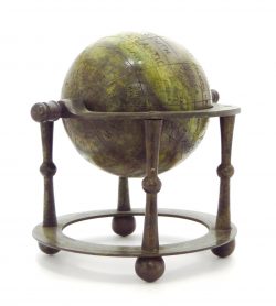
€180.000,00 Categories: Cartography/Globes, Golden Age, Handcoloured, Highlights, History 1715 - Amsterdam, Gerard & Leonard Valk Nr. 12333
A magnificent and rare, early 18th century, 46 cm. (18 inches.) celestial table globe produced by Gerard and Leonard Valk. First state. Made of a set of beautiful original hand-colored, copper engraved gores. With a wooden horizon ring; a highly unusual two-pointer brass hour ring (a small, thin metal circle on the top of a [...]

€23.500,00 Categories: Bibles/Bindings, Cartography/Globes, Highlights, Religion 1657 (colophon Vol.2: 1655, Vol.3: 1656)/Apparatus: 1673 - London, Thomas Roycroft/Apparatus: Zürich, Heinrich Bodmer Nr. 12173
Biblia Sacra Polyglotta, Complectentia Textus Originales, Hebraicum, cum Pentateucho Samaritano, Chaldaicum, Graecum. Versionumque antiquarum, Samaritanae, Graecae LXXII Interp. Chaldaicae, Syriacae, Arabicae, Aethiopicae, Persicae, Vulg. Lat. Quicquid comparari poterat. Cum Textuum, & Versionum Orientalium Translationibus Latinis. Ex Vetustissimis Mss. Undique Conquisitis, optimiisque Exemplaribus impressis, summâ fide collatis. Quae in prioribus Editionubus deerant suppleta. Multa antehac inedita, [...]

Original price was: €6.500,00.€4.500,00Current price is: €4.500,00. Category: Cartography/Globes 1706 - Overwaart, order van de Edele Heeren Erfwatergraaf en water Heemraden Nr. 11630
Uytgegeven door order van de Edele Heeren Erfwatergraaf en water Heemraden van den selven Overwaert in’t Jaer MDCCVI.” (cartouchetitel). “Het Heemraatschap van den Overwaart Groot 12728 1/6 mergen, gesticht by hertog Albrecht van Beyereb, Ao. 1366.” (boventitel). Gegraveerde wandkaart door Mattheus van Nispen (landmeter) en Jan van Vianen (graveur), gedrukt op 4 losse, groot folio [...]