
€4.500,00 Categories: Bibles/Bindings, Cartography/Globes, Geschiedenis, Highlights, History 1743 - Antwerpen, Jan Mourentorf Nr. 12622
(titelprent, 10) z.p. Origineel Leer met ribben, stempels, hoeken en sloten, Folio. H. 37,5 x L. 26 x B. 13 cm. De ‘Moerentorfbijbel’ is tot het begin van de twintigste eeuw gebruikt als standaardvertaling voor rooms-katholieke bijbellezers. Bijzonder is dat door dit werk heengebonden is, naast de serie van 6 uitvouwbare kaarten, uitgegeven door Jacob [...]

€20.000,00 Categories: Bibles/Bindings, Cartography/Globes, Golden Age, Handcoloured, Highlights 1714/1713/1715 - Dordrecht, Jacob and Pieter Keur, and at Amsterdam, Pieter Rotterdam and Pieter Rotterdam Jr./ Basnage, Amsterdam, Jacob Lindenberg Nr. 12621
2 werken in 1 band, (gegraveerde titelpagina, 19) 302, (2) 134, (12) 164, (2) 66 folia. Origineel Leer met ribben met hoeken en sloten, Folio, H. 47,5 x B. 29 x D. 14 cm. Statenvertaling, bevattende het Oude en Nieuwe Testament en de Apocriefen. Geïllustreerd met een gegraveerde titelpagina, 5 ‘grote Keurkaarten’ door Bastiaan Stoopendaal [...]

Original price was: €1.250,00.€750,00Current price is: €750,00. Categories: Cartography/Globes, History 1828 - Paris, Julie Bouesche Nr. 12553
In-folio (32,3 x 22,6 cm), [2] ff, 8 double maps, 10 plates each with a page of explanations, [1] f (table of geographical & spherical figures contained in this Atlas). The maps show the world map, Europe, the Kingdom of France (2x), Asia, Africa, North America, and South America. The plates show the terrestrial globe, [...]

€12.500,00 Categories: Cartography/Globes, Handcoloured, Highlights, History 19th cent. - s.l., s.n. Nr. 12578
The 4.25 inch. (10 cm.) spheres applied with twelve printed gores and polar calottes pivoted via the poles within brass half-meridian rings, each mounted on top of alabaster columns with molded capitals, notable entasis to the shafts and Tuscan-style bases, the plinths with gilt fluted black marble cavetto top moldings and roundel-centered skirts incorporating shaped [...]

A rare pair of miniature terrestrial and celestial globes, each with 12 hand-coloured engraved paper gores, over a papier mâché and plaster sphere. Diameter globes: 7 cm. Total high: 14,5 cm. The globes have been cleaned and re-varnished, and the stands are later.

Original price was: €2.500,00.€1.500,00Current price is: €1.500,00. Categories: Cartography/Globes, Highlights, History, New York 2025 1857 - London, J. Manning Nr. 12592
Miniature terrestrial globe with a diameter of 1,75 inches / 4,5 cm. This lovely miniature terrestrial globe consists of twelve copper engraved, hand coloured gores over a wooden base. The gores are varnished. The colouring is both subtle and original. With a central pin contained in a colourful card box. A little about miniature globes: [...]

€9.500,00 Categories: Cartography/Globes, Geschiedenis, History 1772 - London, Robert Sayer Nr. 12600
Large World map by Samuel Dunn, 140 x 120 cm. “London, Printed for Rob.t Sayer, Map & Printseller, No. 53 in Fleet Street, as the Act directs, 20th November 1772.” “S. Dunn Teacher of the Mathematics LONDON. Boards Young Gentlemen, & Teacheth Pennmannship, Merch.ts, Acc.ts, Navigation, Fortification, Astronomy &c. CHELSEA”. Pasted text on top left [...]

Original price was: €1.250,00.€750,00Current price is: €750,00. Category: Cartography/Globes 1677 - Dordrecht, Symon Onder de Linde Nr. 12528
2 delen, (titelprent, 1, portret,16) 688, 689-1358 (22) p. p. Origineel Leer met ribben, goud-bestempeld, 4° Beschrijving van de stad Dordrecht door Matthys Balen 1611-1691, het werk bevat een toegankelijke beschrijving van de vroege geschiedenis van deze belangrijke Nederlandse stad. Rijkelijk geïllustreerd met een titelprent, een portret van Balen, beide gegraveerd door Romeyn de Hooghe, [...]

Original price was: €900,00.€540,00Current price is: €540,00. Category: Cartography/Globes 1745 - London, Thomas Wright Nr. 12536
(VIII) 190 p. Contemporary gold-stamped Leather, large 8°. With 7 folding plates, complete. Made for Thomas Wright, mathematical instrument-maker and E. Cushee, globe-maker at the Globe and Sun, between St. Dunstan’s Church and Chancery-Lane, both in Fleet-Street. Joseph Harris (1703-1764), was a blacksmith, astronomer, navigator, economist, natural philosopher and government adviser and King’s assay Master [...]
€22.500,00 Categories: Cartography/Globes, Highlights 1754 - Paris, Longchamps et Janvier Nr. 12551
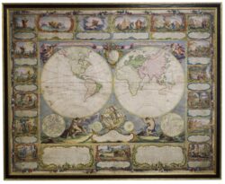
Wall map of the world in two hemispheres printed on two sheets, depicting the Eastern and Western hemispheres supported by two male figures, decorated at the bottom right and left with two celestial hemispheres (boreal and southern) and at the bottom in the middle with an armillary sphere, in addition. Size 115 x 145 cm. [...]

€25.000,00 Categories: Cartography/Globes, Highlights 1740 - Amsterdam, Johannes Covens & Cornelis Mortier Nr. 12552
The first wall map of the Seven Provinces of 1651, re-issued as ‘Stoel des Oorlogs’ by Covens & Mortier. Size 136,5 x 172 cm. The first issue of the present wall-map is known to be included in the Klencke Atlas in the British Library; the second edition, by son Dancker Danckerts, is present in the [...]
€6.750,00 Categories: Cartography/Globes, Highlights 1528 - Antwerpen, W. Vorsterman Nr. 12488
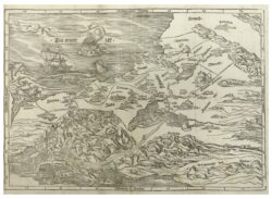
Goed en fris exemplaar. Afmetingen: H. 30 x B. 40 cm. In de Bijbels die vanaf 1528 gedrukt zijn komt meestal een houtsnedekaart voor. Deze is gebaseerd op een grote zesdelige wandkaart, die Lucas Cranach omstreeks 1510 maakte ter herinnering aan de pelgrimstocht naar het Heilige Land in 1493, gemaakt door Frederik de Wijze, de [...]